
COHOKIA MOUNDS DESIGNATED NATIONAL HISTORIC LANDMARK
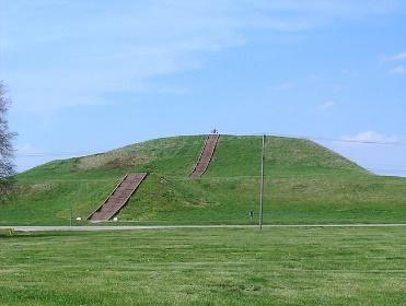
Located in Illinois, east of the Mississippi River & St. Louis, Missouri, Cohokia Mounds are the pre-eminent example of a cultural, religious & economic center of the Mississippian culture, which extended throughout the southeastern U.S. from A.D. 1000-1350. The original complex of mounds, homes, and farms covered over 4000 acres. Population estimates for Cahokia proper range from 10-20,000. “Greater Cohokia” may have had upwards of 40-50,000. The site consists of 51 platform, ridgetop, and conical mounds. Dominating the site is “Monks Mound,” the largest Indigenous earthen structure north of Mexico. It covers 6 hectares and rises in 4 terraces to a height of 30 meters. The mounds served as foundations for public buildings & as burial mounds. There was also an astronomical observatory (“Woodhenge”) with a circle of wooden posts aligned with the annual movements of the sun. Listed on the National Register of Historic Places in 1966, it became a UNESCO World Heritage Site in 1982.
Source:
  “Cahokia Mounds State Historic site: World Heritage Site,” U.S. National Park Service.  Retrieved 1/4/2022, Cahokia Mounds State Historic Site: World Heritage Site (U.S. National Park Service) (nps.gov)
Wikipedia
Photo:  U.S. National Park Service, undated. Public Domain.
